Prehistoric Period
For several years the Department of Archaeology and Art History, University of Siena, with other universities,is making some researches in the territory of the Maremma Regional Park to show the human presence in the prehistoric period. The results of the first research in the Park suggest that the prehistoric heritage was known only to a small part of the territory and that the Park can be a sample area to study the reconstruction of the early history of the Maremma area in general.
There are three sites on where researches are concentrated: the Buca di Spaccasasso, the Sasso delle Donne and Scoglietto.
In the first one the researches have shown several passages of cinnabar extraction cycle and the results are that the mining of Spaccasasso was the only extraction location of this mineral known in Italy and in Europe, at the time.
The Sasso delle Donne site, which is in the inner side of the northern side of the Uccellina Mountains, the human presence and the activities connected to the stone processing are perhaps to be linked with the particular presence of silicon raw material. This discovery is particularly important.
Even in the Scoglietto area investigations in process are aimed to find any archaeological evidence of prehistoric period from the Paleolithic to the metals ages. In this area the findings indicate the presence of a funerary practice ascribable to the Copper Age.
Roman period
The Alberese area is very important because it preserves archaeological contexts of great importance and suggestion, placed in a natural environment that differs little from the old one, still visible in the connection between the sea coast, the river and the countryside, as now crossed by a big road, which strategically connected the territory with Rome. Particularly in the last years intense archaeological researches have been done and so many architectural complex have been discovered from the sacred area of Scoglietto to the commercial site of Spolverino, with a rich recovery of finds.
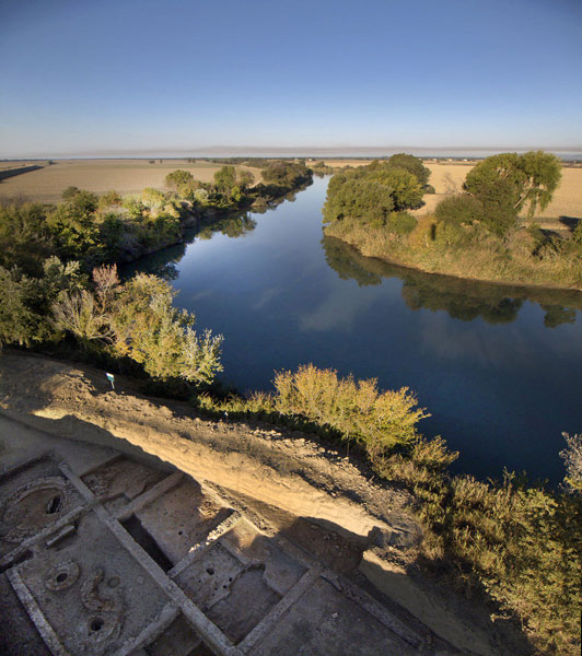
In Roman period the Grosseto Maremma area had its main center in Rusellae, Etruscan town, that became a Roman colony. The town controlled a larget territory between the Metallifere hills, the coast, the Uccellina Mountains, the Ombrone river and the Amiata Mountain. The large Lake Prile, which gradually became a swamp and of which some traces remain in the Diaccia Botrona wetland, occupied a good part of today’s Grosseto land and it was used for its water resources and as a communication way. Roselle also used the presence of the Ombrone river, partially navigable at the time, the presence of an important communication way such as the vetus Aurelia Road, and it controlled the Amiata woods, as we are informed by the Roman historian Livio (XXVIII, 45, 14 ). The town was built, so, in a strategic point for communications between the hinterland and the Tyrrhenian coast. In this context the new discovered sites in Alberese, inside the territory managed by the Maremma Park, which consist of a Roman sanctuary, in Scoglietto, dedicated to Diana Umbronensis and of a manufacturing district built on the river, in Spolverino location.
The sanctuary was built during the Roman development of the area, at the end of the III century BC and it was used until the Christian age (IV century A.D.). An inscription on the marble, found in the site, testifies to the presence of a cult to the ancient Italic goddess protector of hunting, forests and rivers. At the beginning of the II century BC, a small chapel was dedicated to the goddess where the offerings were collected. At the beginning of the I century A.D. in the Scoglietto promontory a temple and a collegial area with 7 rooms were built, and the small chapel was abandoned.
The entire complex went through a period of crisis at the end of the II century A.D., when the area was abandoned and the temple was restored, the temple that, during the IV century A.D., after the Thessalonica edict (380 A.D.), was finally forgotten. A hut was built to its ruins, a witness of a new form of employment until the end of the VI century A.D., when the Scoglietto site was forgotten.
A few kilometers from Scoglietto, on the last part of the river Ombrone, the Spolverino district is an important manufacturing district of the Roman period, specialized in different productions. The proximity to the river allowed the transport by sea to reach Rusellae and the presence of the Aurelia road guaranteed the land traffic. The first occupation of the site dates back to the beginning of the I century A.D., but at the end of the II century A.D., cause to the crisis in the Roman Empire, the small local shops became large production workshops. The glass workshop was implemented by the build of a larger structure with circular furnaces (1.40m diameter), a work table and a large tempering furnace (4m diameter). The bone and metals workshops developped too, in particular lead, giving to the site the appearance of an active manufacturing complex.
All workshops were served by a shared kitchen, inside of which there was a place (lararium) consecrated to the protective goddess of the home. The complex remained in use until the late V century, then a small necropolis was built on its ruins, composed, at the time, of 4 buried. Cause the floods of the river Ombrone, the area was converted to agricultural territory since the first centuries of the Middle Age and there are no more buidings until the VI century A.D.
From 2013 some archaeological researches are in a site in Prima Golena location. The settlement was founded during the Roman Republican period (III-II century B.C.), along the coastline of that period (about 6km from the current one) and it continued to be in use until the end of the V century A.D.
It has a rectangular plan with a number of rooms around an atrium. Two open spaces located on the northeastern part of the complex in the direction of the Aurelia vetus road complete the building. The comparison with the Tabula Peuntingeriana and the calculation of the Roman nautical miles take to identify the site with the Umbro Flumen Positio.